

Subseasonal forecast
Valid from jun 22-jul 6 , 2025
(4 weeks)
General comment:
Fig. 1. Weekly precipitation forecast by region for the next 4 weeks.
1.Forecast from jun 9-15, 2025
Probability of extreme event: low (around 20%)
Prognosis uncertainty: medium
2. Forecast from jun 16-22, 2025
Moisture levels will continue to rise in the Caribbean, favoring seasonal rainfall, although a bit of rain in the early days. Rainfall in the Central Pacific, South Pacific, and Central Valley will also be normal (60-120 mm weekly in the Pacific, 40-90 mm in the Caribbean and North Pacific, and 40-90 mm in the Central Valley).
Probability of extreme event: low (around 20%)
Prognosis uncertainty: medium
3. Forecast from jun 23-28, 2025
This week, humidity levels will remain low, with the sun shining brightly in the center and north of the country. Clear conditions will favor warmer-than-normal temperatures. The Pacific will be drier than normal, while the rest of the country will experience normal conditions.
Probability of extreme event: low (around 30%)
Prognosis uncertainty: medium
4. Forecast from jun 29-Jul 6, 2025
Very weak trade winds and the presence of the Intertropical Convergence Zone over the country. The Intertropical Convergence Zone is expected to favor rainy conditions throughout the Pacific and Central Valley.
Probability of extreme event: low (around 20%)
Prognosis uncertainty: high
Forecast of extreme events from jun 9-15, 2024
This week, there is a moderate possibility of cyclogenesis, meaning a low-pressure system could form north of Panama, generating rainy conditions in the southern Pacific of Central America. There is a high possibility of a rainy scenario in Costa Rica and a very low possibility of direct impact from a tropical cyclone.
Fig. 2. Forecast of extreme events for the next 2 weeks (training areas).
Forecaster: Daniel Poleo
Maps: Nury Sanabria Valverde
Unidad de aplicaciones climáticas
Departamento de Desarrollo/IMN
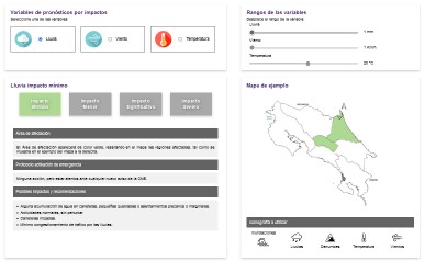
Practical guide impact-based forecasting
Documental and interactive guide who explain how impact based forecast warnings are made.
See more...
Ephemerides
In this section you will find all the necessary information about sunrises and sunsets of the Sun and Moon, as well as all the information about the corresponding lunar phases.
See more
Weather in Costa Rica
The aim of this study is to provide statistical precipitation and temperature information three time periods : the database for online reference 1961-1990 , the period of observation of variability in the past 15 years ( 1991-2006 ) and the stage climate change estimated for 2070-2100.
See more...